iSTAR D
Three Brits, a Canadian and an Aussie head off into the Ellsworths…
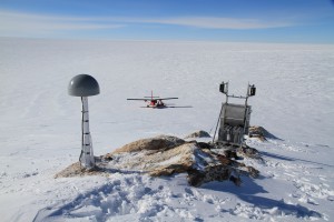
As part of the iSTAR-D project, three GPS receivers were permanently installed throughout the Ellsworth Mountain region of West Antarctica. These receivers, combined with sampling of erratic boulders, aim to provide more information on local ice history and rates of isostatic rebound, which in turn can be used to improve models of glacial isostatic adjustment (GIA).
The project commenced, as most of them do, with our arrival into Rothera a few days after Christmas. The delay in the arrival of the JCR gave us a chance to meet the rest of our team. Steve King and Vicky Auld were our pilots, Roger Stillwell was our field assistant, Mike Bentley was responsible for erratic sampling and other geological-wizardry, while I was responsible for the geodetic science and GPS installations.
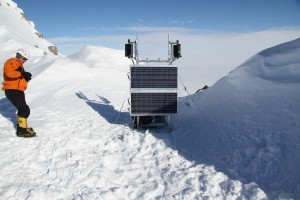
On January 6th, the weather finally cooperated and allowed us to start transiting to Union Glacier – our base for the duration of our field research. On the morning of January 8th, we set out for our first site at Mount Johns – a small, exposed nunatak approximately 90 miles west of the Ellsworth Mountains. There was already some existing hardware at this site from a previous campaign, and combined with the fact that it was the closest of our three designated sites, it served as a good shake down for everyone in the team. After hauling some heavy gear up a very steep slope, Mike and Roger ventured off to do some erratic sampling while Vicky, Steve and I completed the installation of the GPS receiver. Thankfully everything operated as expected and with the appropriate logging LED’s illuminated on the GPS hardware, we returned to Union around 22:30 (UTC).
The following day (January 10th) we made an attempt at our second site; Martin Hills. This site was approximately 170 miles south-west of Union Glacier, the furthest of our three sites. On our fly past we quickly spotted a slab of north-facing bedrock that would be suitable for the GPS receiver installation. After some more circling, it became evident that we’d have to land away from this site and taxi over to it, or haul the gear by hand. After touching down, we quickly realised that the distance and slope over which we had to haul the gear would require several days work. More importantly, the wind was getting too strong for us to safely leave the aircraft unattended; we made the decision to abandon Martin Hills and return to Union to re-evaluate.
January 11th allowed us to go and explore our next site; Mount Woollard; another of the very few nunataks that poke through the ice sheet and give us the opportunity to mount our equipment on solid rock. As with Martin Hills, we soon spotted some suitable bedrock from the aircraft before touching down nearby. Unlike Martin Hills, the winds were relatively calm here, allowing us to taxi reasonably close to the installation site. Mike and Roger soon ventured off to traverse a ridge to the east for geological sampling, while Vicky and Steve completed the installation of the GPS hardware. Meanwhile, I was busy installing the GPS monument in the quartzite nearby. After another long day in the field, everything was operating as expected, allowing us to return to Union around 2200 (UTC).
After a day on the ground due to bad weather, we were able to fly out to our alternate site at Nash Hills on January 13th in the hope that we could deploy our Martin Hills receiver there instead. On the summit we again spotted some suitable granite slabs that would be perfect for the GPS installation, while some of the nearby ridgelines also looked very promising for Mike’s sampling. Despite our best intentions, the sastrugi had other ideas; our first ski drag soon revealed it was as hard as concrete! Even with the best efforts of two skilled pilots, we were still unable to find a safe place to land our aircraft. With fuel reserves running low, we had no choice but to return home for the day, saying goodbye to a seemingly perfect installation site in the process. Frustrating, but just one of the things that Antarctic fieldwork can throw at you.
With unsuccessful installation attempts at both Martin and Nash Hills, Mike and I had to re-evaluate our options. With some assistance from Matt King back in Australia (with access to satellite imagery) and other scientists who were staying at Union as part of the US POLENET project, we selected another area in the Mid-Ellsworth’s that we believed would be suitable for our last installation. At this point in our trip, the weather decided to play hard ball for a few days, leaving the iSTAR-D team stranded at the Union Glacier camp for three days. The camp itself is run by the privately-owned Antarctic Logistics and Expeditions (ALE), who provide accommodation and hospitality services to tourists, private expeditions and a range of national science programs. Time was passed by teaching others to play poker, bike riding – yes, that’s right, bike riding – and enjoying the warm showers provided by ALE!
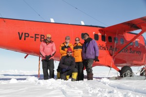
January 18th finally gave us the opportunity to explore our final alternate install site. Had we not found anything suitable on this flight, we would have had to depot the remaining GPS hardware and return to Rothera. As we neared the end of our reconnaissance flight, several of us simultaneously spotted a suitable piece of bedrock. When Steve announced he could land there safely, we knew we were in business! By this stage of our trip, we were running like a well-oiled machine. After finding a suitable piece of bedrock for the installation, the plane was quickly unloaded and assembly of the major components was underway. Testing revealed that, as with the previous two sites, everything was operating as expected. With time up our sleeves, we took a few minutes to snap a group photo before starting the long transit back to Rothera.

The iSTAR D team (L to R: Roger Sitwell, Mike Bentley, Jack Beardsley (front), Vicky Auld and Steve King)
Despite the weather delays and unsuitable surface conditions around two of our proposed sites, we completed all our research objectives. A massive thanks needs to go out to our fantastic team in the field; Steve, Vicky and Roger, you’re all superstars and Mike and I would have been stranded without you! Thanks should also go to the fantastic group of people who took good care of us at Union, as well as everyone who provided continual support from back at Rothera.
Jack Beardsley iSTAR-D Geodesist and GPS Technician


