

by Povl Abrahamsen
In October 2011 a NASA airplane flying over Pine Island Glacier observed a large crack going all the way across the ice. This was the first sign that the glacier was about to calve a large iceberg into the Amundsen Sea. Glaciers are large rivers of ice – the ice flows very slowly from the interior of Antarctica where it falls as snow, down to the coast. When the ice reaches the sea, it will float; the floating part it is called an ice shelf. And eventually bits will break off as icebergs, which drift out to sea, where they gradually break up and melt.
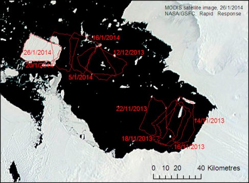
Since the crack on Pine Island Glacier was first observed, it got wider and wider, until the new iceberg finally broke free in November 2013. After picking up speed, the iceberg moved at around 4 km per day, until it ground to a halt in early December. The iceberg is almost 450 m thick; most of the ice is under the surface, and a corner of the iceberg hit a part of the seabed that is around 400 m deep. Slowly the iceberg turned around that corner, until it finally started moving again in mid-January 2014. At the moment the iceberg is still moving. We are trying to keep an eye on it with satellite images, like the picture below, which shows some of the iceberg’s past outlines. Although the JCR can break its way through sea ice, the iceberg is much larger and heavier than the ship, so we will have to steer around it – and hopefully get a nice view of the iceberg from a safe distance!
Satellite image of Pine Island Bay, taken on 26 Jan. 2014. Pine Island Glacier is in the bottom right. The dark areas are open water, the lighter parts are ice: there is ice on much of the land, floating freshwater ice (ice shelves and icebergs – both formed from snow) and sea ice (frozen seawater).
Via: Ocean2ice blog
