

Overnight we sailed east of Burke Island, with ice caps in sight on both
sides of the ship at some points, collecting new ocean depth data and
more CTD data. We have left the sea ice behind now, and whilst we’ve
seen fewer seals and penguins, a couple of killer whales were spotted
last night!
Today started with sunset merging beautifully into sunrise (without the
sun dipping below the horizon), and there is now blue sky and calm seas
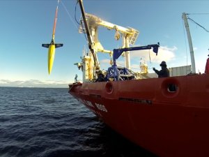
– a good start to our first Seaglider deployment! Although it’s sunny
and calm, it’s very cold outside – the temperature is hovering around -5
degrees C + wind chill!
All preparations on deck went smoothly, and the Seaglider will now
travel east-west just south of Burke Island for the next couple of
weeks, collecting temperature, salinity, dissolved oxygen and
chlorophyll data. [Ben – can you add in a line about how (well) it’s
diving – I don’t want to jinx it by typing it ahead of time!!]
Like the CTD data, this information can help us identify water that’s
come from different places – for example, except for the surface layer
there are no processes that will change the salinity, until that water
mixes with water of a different salinity. We’re interested in this so
that we can see the path that the ‘warm’ (2 degrees C) water takes after
it has come onto the continental shelf, as well as identifying where the
meltwater from the glacier is.
Via: Ocean2ice blog
