

This article, written by Ashly Fusiarski, a field assistant at the British Antarctic Survey, describes how he helped set up the remote field camps and equipment for the iSTAR tractor train in the 2011-12 Antarctic summer. It was written in 2012 after he returned to Rothera, where he spent the next Antarctic winter.
Sat in the co-pilot seat of a DHC-6 Twin Otter, flying with an air speed of 140 knots and an altitude of less than a hundred feet was the start of my field season on Pine Island Glacier. The sky was powder blue and the ground was beaming white with snake like trails of drifting snow weaving and scouring their way along with the wind. Up to that point I had been in the field for a month already, based at the British Antarctic Survey (BAS) forward operating hub for deep field projects, Sky Blu.
Glaciology field camp on Pine Island Glacier, West Antarctica. Photo: Andy Smith.
Sky Blu is a remote, summer only encampment, which, by the strong winds throughout the year, is blown clear of snow to reveal pure, uniform, blue ice. This ice is utilised by BAS as a runway which can accommodate BAS’s DHC-7 (known as the Dash 7). The larger payload of the Dash 7 means it can depot larger quantities of aviation fuel which is then used by the Twin Otters to input remote field parties. After three weeks at Sky Blu, establishing camp, inputting science equipment to other field parties close to the Ellsworth mountain range and retrieving GPS units from the surrounding ice streams my own team arrived along with two Dash-loads of cargo. Each field party is given a call sign; we were to be Sledge India. Sledge India was to be headed by Dr. Andy Smith with Gabriel Chevailer forming the science team and Ian Hey and I as their Field Assistants. The objective was to collect high quality data adding to the data set of previous projects to further the understanding of Pine Island Glacier (PIG).
PIG is a large glacier on the West Antarctic Ice Sheet (WAIS) and is remote even by Antarctic standards. At over 800 miles from the nearest research station it takes a lot of effort and organisation just to get there. Fuel has to be cached along the way as each input flight is a compromise between weight and distance. The more weight a Twin Otter carries the less distance it can travel and the inverse is also true. Tons of equipment needed to be flown to PIG in order to carry out the necessary research but because it is so far away the Twin Otters would reach their maximum payload in fuel just getting there and back before any equipment was loaded on board. So to make it possible, an aircraft will fly out fuel drums and deposit them on the way to PIG before turning around to Sky Blu. Another aircraft loaded with science equipment or Clatch as it is colloquially known, will then follow on and use the previously deposited drums to refuel and carry on to the destination. This was repeated over seven times until all of the people, equipment and living units of Sledge India were in place. Over a dozen projects all require the use of the four BAS Twin Otters who often require several flight loads each. Months of planning and contingency planning at Cambridge HQ allow the teams to be input as efficiently as possible with allowances for quick changes and the fickle weather factored in.
PIG is an extremely important area of the Antarctic from a scientific point of view. The glacier is descending rapidly into Pine Island Bay and the Amundsen Sea. It shows signs of acceleration and significant warming contrasting greatly with East Antarctica. The U.S. Antarctic Program, NASA and BAS are all studying PIG (along with its neighbouring glacier, Thwaites) with great interest. The glacier is over 2 kilometres thick and is moving 3 m a day. So in the two months we were there our camp had moved 120 m from its original location and now in the following southern summer our camps original location on the ice will be 1 kilometre downstream of the GPS waypoint we were initially inputted. If you stood in the town of Chamonix in France and looked up to the top of the Aiguille Du Midi or imagine seven times the height of the London Shard building that is how thick the ice is. With so much ice that is currently on land, which is heading into the sea, so quickly, it has the potential to affect the whole planet dramatically. A large influx of ice could change the temperature of the polar seas effecting polar oceanic currents which would impact on climate and bio-diversity all over the world, global sea level rise and the potential displacement of populations could all be outcomes of a de-stabilised WAIS of which Pine Island Glacier is believed to be one of the keys.
To understand the mechanics of the glacier and create accurate models to predict what will happen in the future as much information needs to be gathered as possible. We were sent in to survey PIG using a variety of methods to collect quality data which would be used to work out the basal conditions and accurately trace the movements of the glacier. The emphasis was on gathering ‘quality’ data which meant working over relatively small areas and being meticulous in the execution of the tests. Over years BAS and other researchers have been slowly gathering tiny clues and pieces of the puzzle to further their understanding of the area. It takes time as well as lots of effort to produce accurate predictions. Vagueness and ambiguity are not part of the game plan.
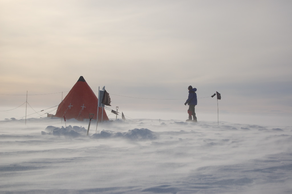
The BAS air unit worked tirelessly to input us into our location. Gabby and I were on the final input flight were we would join Andy and Ian. They had been sent ahead of us to establish camp as Gabby and I remained at the intermediary depot to refuel the aircraft and provide weather observations for the pilots. It had taken a week since the team regrouped at Sky Blu for us all to arrive at India one eleven, the code given to our final destination. The sun was shining but there was a 20 knot wind. Gabby and I began setting up our tent. Andy and Ian boarded the very same aircraft we had just stepped off and took off to reconnoitre the glacier 50 km downstream. Part of the plan was to install an overwintering GPS station there but it is a known crevassed area, the reconnaissance flight was to see if there was a possible route that could be taken on snow mobiles. When one stands on Pine Island it has the appearance of been totally flat (which it is not). It is like standing on a frozen ocean, with nothing on the horizon whatsoever. On a clear day the horizon cuts through the sky like a razor blade forming a perfect straight line. Because of this apparent flatness it was difficult to imagine any crevassing at all but upon Ian’s return he would report seeing hundreds of crevasses with evidence of collapsing snow bridges and all less than twenty minutes flight time downstream. The traverse on snow mobiles was written off almost straight away. It would have been an expedition in its own right which could have quite easily seen failure or even catastrophe and we had lots of other work to do. I trusted Ian completely but I still assumed he’d exaggerated somewhat as to the frequency and size of the crevassing but I would later find out for myself how this benign looking glacier was in fact riddled with seemingly bottomless icy caverns.
After the recce flight we were again all together at India one eleven. This time the plane left leaving the four of us alone on the vast flat white to prepare the camp and science equipment and carry out the various surveys for the next two months. During that time we would celebrate Christmas and New Year’s Day, ex-BAS employee Felicity Aston would be the first women in the world to ski solo across Antarctica, we would hear of the Prime Minister congratulating everyone working for BAS for their continued efforts in polar research on the day of Captain Scott’s centenary and the start of one of the most pioneering scientific programmes, the iStar project, would commence via our location.

Surface detonation during a seismic survey of Pine Island Glacier. Photo: Roger Stilwell.
During the summer in Antarctica, at our latitude of 75 degrees south, the sun never sets. The only thing to preclude any work is the changeable weather. Sometimes we had blue skies and sunshine above us but if there was a wind over 10 knots we would have to postpone seismic work for two reasons depending on what stage of the process we were at. Seismic work involves creating a shockwave which penetrates through the ice and is reflected back from the sub-glacial floor. These reflections are recorded using long lines of geophones which collect data that is used to profile and map the basal conditions. Often the best way of creating the shockwave needed is to use explosives. To detonate the explosives an electrical current is passed down the det. cord. The problem with a 10-knot wind is that this creates drifting snow, which, because it is so dry, can generate static electricity and theoretically detonate the charge accidentally and unpredictably. This may seem very unlikely but when one is holding a kilogram of explosives between one’s thighs whilst priming the shot, any risk at all of detonation is unacceptable. The second problem the wind creates is that even if the seismic lines are primed and safely buried in bore holes ready to shoot, the geophones are so sensitive that they record the sound of the drifting snow which corrupts any recordings to point where they are unworkable. On the windiest continent on the planet this can create delays and therefore if there was a 26 hour weather window, we would work 26 hours straight. “In the Antarctic good weather cannot be wasted” as stated in BAS’s operating manual.
As well as profiling the basal conditions of the glacier, over-wintering global positioning satellite stations were installed, which record the location, time, date and elevation of the unit. These can then be used to track the movement of the glacier and used in computer models to predict its next movements. The GPS itself is not much bigger than a pint glass, but to power it over the next two years, 4 car sized batteries, 1 solar panel and 4 small wind turbines were also installed at each location. The locations were 50 km apart from each other and were reached using snowmobiles. A traditional Nansen sledge made from ash wood, lashed together with leather thronging and balloon cord carried emergency living equipment and was towed behind the ski-doo in case we couldn’t make it back to camp for any reason. During the field season the four of us would individually cover approximately 2000 km on snowmobiles.
Life on PIG was surprisingly comfortable. The living system we used was fundamentally the same as the one that has been used for the past century. The two-man tents, stoves and sledges are all the same albeit updated and finely tuned. The sleeping bags are tried and tested and a combination of modern textiles finished off with a sheep skin create the mattress that we slept and lived on when not working during lie-up days: days of poor weather when no work can be carried out and even leaving the tent can be unadvisable. Towards the end of season we experienced a week of lie-up, the strong winds filled the air with dry, sand like snow which made it impossible to see anything. The antenna for the HF radio we used to keep in touch with base was six meters long and held up off of the surface by a bamboo cane. On returning from the toilet tent one lie-up day I found the bamboo holding up the antenna but still couldn’t see the tent despite it been three meters high at the apex and bright orange. In those conditions it is all too easy to get disorientated become lost just meters from safety. But still, that was just life on PIG and felt completely normal at the time. As time went on the tent would drift in up to half its height until it was necessary to dig steps into the snow going down to the entrance. We washed with wet wipes or had a snow bath and on two occasions we jumped into the tank of the hot water drill that was used to create bore holes for the explosive charge. There we were on a flat white glacier 800 miles away from the nearest tap taking it in turns to have a bubble bath in a giant Zarges box, it was essential to get dry and dressed quickly once out of the water as the -20 temperatures were potentially damaging to extremities.
The works continued as the sun gradually dropped lower and lower in the sky, unperceivable at first until the light slowly began to develop a purple hue. Days before the uplift it almost touched the horizon before accelerating skywards again. The work was physically demanding but life was simple. Every action had a purpose and meant something whether it was the difference between being warm or cold, hungry or well fed or obtaining good data or bad. It meant each action provided some sort of satisfaction and the benefits of everything we did could be easily seen or felt by a measure of comfort or progress made. Conversations were good humoured but purposeful with a clear direction. It can be serious if you get it wrong and even small mistakes have disproportionately severe consequences. Subconsciously we had been communicating with each other differently, just slightly more efficiently and more precisely. I had not realised this until I was sat at the dining table on base three months after returning, where for a while any sarcasm or small talk went straight over my head, we just hadn’t expressed ourselves that way in the field, we hadn’t needed to fill the time that way. Everything seemed slightly nosier and the buildings felt bigger and more sprawling. Living in the field had felt more normal than ‘home’ on base.
We had had several visits from aircraft during the field season to input instruments for different projects as well as a two-man team acting as part of the iStar project. The iStar project is intended to survey and research the tributaries draining into the Pine Island basin but at the same time it addresses the issue of inputting equipment. Instead of relaying flights as we had had to, the iStar is to use PistenBully’s to drag a caboose and thousands of litres of fuel in bladders which will be towed in a train like fashion. The PistenBully’s are the same as used in the Alps for grooming the ski slopes. The iStars’ are modified for polar use. They are each 450 bhp and can tow forty-four tons or more. The iStar traverse leader Simon Garrod and field assistant Paul Torode were dropped off at our camp and after some poor weather drove to the Abbot Ice Shelf on the west coast of Antarctica where they were trying to find a suitable location for the RRS Ernest Shackleton (one of the BAS vessels) to moor and unload the PistenBully’s, the caboose, all of the fuel and two mechanics/vehicle operators. At India one eleven we listened with anticipation as we heard reports of “sea ice as far as the eye can see” over HF radio and discussions over whether or not to commit The Shack to making the journey from the Falkland Islands to the Abbot with the possibility of it not being able to get close enough to unload the cargo and have to turn back with the task uncompleted. Dr. Andy Smith’s opinion was sought as it transpired he was and indeed still is the programme manager. “It would be nice to at least try…” was the response. With a willing captain The Shack set sail. The outcomes were uncertain and there were mixed reports, at one point it sounded like the ship had been unsuccessful only for the following update to say they had had a lucky break in the sea ice and all the cargo and personnel were safely on the ice shelf and beginning their traverse. It was tremendously exciting, listening to history in the making, as one of the most inaccessible but scientifically significant parts of the planet had just been opened up to research through an extensive amount of team work and planning.
As I sit here in the library of Rothera research station, teams wait for a low pressure weather system to pass through. As soon as the weather breaks the base will burst into life with aircraft deploying people to locations across WAIS and the Peninsula for a variety of scientific purposes. The Sub-glacial Lake Ellsworth team will depart to drill through over 3 km of ice into Lake Ellsworth to potentially find new species of life. The iStar team will head out to their depoted equipment and continue the traverse ready for the 2013-14 season. Other teams will track the speed of glaciers before the potential breakout of ice shelves and monitor any changes. Scuba teams are already monitoring bio-diversity and met teams are monitoring atmospherics along with many more experiments and surveys across the continent. Every season information is slowly gathered and compiled, questions are answered and raised as researchers seek to understand the planet we live in and the climate that affects us all.
